TriTechne
Operations Management System for ISPs

Run your whole network, not just its records.

Atlas is the Operations Management System for Internet Service Providers. Network records, fiber tracing, field crews, construction QA, outages and customer reporting run in one system. It's built and run by TriTechne, a company that builds these networks for a living.

Request a demo
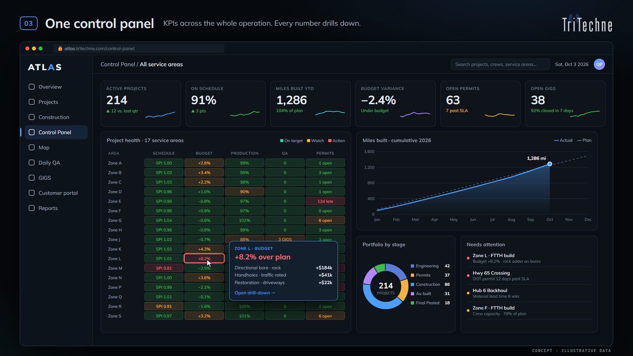
Atlas control panel showing KPIs, project health by service area and miles built
Atlas in 40 secondsConcept
The problem

A records system tells you what's in the ground. It doesn't run the work.

Most ISPs keep their network in a records management system: a map of strands and splices. Everything that happens to that network lives somewhere else. Crews, construction status, QC, outages and customer reporting sit in other apps, spreadsheets and inboxes. Every handoff is re-keyed, out of date, or lost.

Records management + everything else

  • Enterprise GIS licensePer-seat, plus servers to run it
  • Fiber records / design toolAnother subscription, another copy of the map
  • Pole & field collection appData comes back as exports
  • Spreadsheets + BI dashboardsConstruction status lives in someone's inbox

Atlas Operations Management

  • One network recordDesign, as-built and outages on the same map
  • Field app built inCrews work on the live record, even offline
  • Construction QA built inUnits, QC issues and redlines flow back into design
  • Customer & contractor portalEveryone sees exactly their slice, nothing more
The platform

What Atlas does today

Everything below is built and in production. Things that are still coming are listed separately under Coming next.

Network records & map

A true utility-network model: every pole, span, cable, splice and device, with connections stored as records, not guessed from lines on a map.

  • Full edit history on every feature
  • Undo whole edit batches
  • Practice zones that roll back after training

Fiber trace & QC

Trace any strand from the hut to the tap and back. See exactly what each fiber lights, and where the records have gaps.

  • Splice workbook import and checks
  • OTDR results matched to the design
  • Optical loss budgets

Construction tracking & daily QA

Crews log units right on the map. Each morning a QA list shows what's missing, by crew and by day.

  • Inspector issues → crew fix → sign-off
  • Field redlines approved into the design
  • Drops: bury depth, light levels, 811 dates

Field app that works offline

Installs on any phone or tablet from the browser. Download a work area, work with no signal, and it syncs when you're back in range without duplicates.

  • GPS placement and line drawing
  • Photos attached to the feature
  • No app-store install to manage

Outages & storm damage

Cut a cable or drop a device on the map, and Atlas traces downstream to every tap and subscriber affected.

  • Storm damage logged as it's found
  • Damage reports of units and materials for insurance claims
  • Test cuts for planning

Customer & contractor portal

Give owners, partners and subcontractors their own login, scoped to a customer, a project or a single work order.

  • Required two-factor sign-in
  • Dashboards, trackers and maps per customer
  • Quarterly access reviews

Reports & deliverables

Bill of materials, units, footage and miles built, plus weekly, monthly and year-end report packs that run on their own.

  • Excel and CSV exports
  • GeoPackage, shapefile, KML/KMZ, GeoJSON
  • 811 locate packages per feeder

Broadband sales & FCC data

Match FCC broadband serviceable locations to your network, then build target lists of passings you can sell today.

  • Fiber miles and passings by area
  • Sales target lists
  • Hand-off to marketing tools by API
See it

Videos

Short walk-throughs of Atlas at work. Videos marked Built feature show what Atlas does today on an illustrative network. Videos marked Concept may show capabilities still on the roadmap.

Compare

Operations management vs. records management

Most tools are excellent at one job: the map, the fiber records, or the poles. Atlas is built to run the operation around the network, in one system.

Capability AtlasTriTechne ArcGISEsri VETROFiberMap IQGeo 3-GIS Katapult Pro
✓ Included ~ Partial, add-on, or needs configuration – Not a focus / needs another product ? Not stated in public materials

Comparison based on each vendor's public website and documentation as of October 2026. Products change; check with each vendor for current features. All trademarks belong to their owners. Atlas is not affiliated with or endorsed by these companies.

Why Atlas

Six reasons to pick Atlas

01

Built by people who build networks

TriTechne designs and builds fiber for electric co-ops. Atlas came out of that work, so every screen answers a question a PM, designer, splicer or crew lead actually asks.

02

Operations, not just records

Design, construction, as-built and outages run on the same system. A redline from the field updates the design. A cut cable shows the subscribers out. Nothing gets re-keyed.

03

Your data, in open formats

Atlas runs on PostgreSQL/PostGIS. Export your whole network to GeoPackage, shapefile or KMZ any time. No proprietary file you can't open without us.

04

Bring everyone in, safely

Owners, partners and subcontractors each get their own login with two-factor sign-in, scoped to exactly their customer, project or work order. Access is reviewed every quarter.

05

Changes in days, not release cycles

Need a new report, field, or workflow? Our team ships it. Every change is reviewed, tested and deployed through the same controlled pipeline.

06

Built to SOC 2 controls

Two-factor sign-in, least-privilege access, a full audit trail of edits, encrypted connections, and documented access reviews, designed in from day one.

Coming next

On the roadmap

We'd rather tell you what's coming than pretend it's done. These are in active development.

Joint use & make-readyPole audits, attachment records and NESC clearance checks.
Live ONT statusSubscriber status straight from the network, on the map.
Street-level 3D placementPlace features from 360° street imagery with true depth.
CAD drawing exportDirect drawing output for design packages.
Storm operations centerStatewide damage summary and restoration planning (see the concept video).
Questions

FAQ

What's the difference between an Operations Management System and a records system?

A records management system is the map of your plant: cables, strands, splices. An Operations Management System runs the work around that plant: crews, construction progress, QC, outages, customer and contractor access, and reporting. Atlas does both, so the record stays current because the work happens in it.

Do we still need an ArcGIS license?

No. Atlas has its own map, editing, field app and exports. We moved our own network off ArcGIS and checked every feature across with a parity report.

Can we bring our existing data?

Yes. We've imported ArcGIS services, splice workbooks, OTDR results and legacy construction records. Tell us what you have and we'll scope the migration with you.

Can we get our data out?

Any time, in open formats: GeoPackage, shapefile, KML/KMZ, GeoJSON, CSV and Excel.

Does the field app work without signal?

Yes. Crews download a work area before they go. Edits wait in an outbox and sync when the device is back online, without creating duplicates.

How is Atlas priced?

Per organization, not per seat, so you can bring in every crew, partner and subcontractor without counting logins. Contact us for a quote.

Where is our data hosted?

On dedicated servers in the United States, with encrypted connections and two-factor sign-in for every user.

Get started

See Atlas on your own network.

Send us a sample of your data and we'll show you your network running in Atlas: records, traces, crews and a construction view.